
ABOUT THE AUTHOR

One of the backbones of today’s urban planning is efficient property management and assessment. A realtor’s, urban planner’s, or assessor’s work is impossible without proper valuation of housing for sale or rent. But even well-tried industry practices may lack the precision of assessment, especially when there are batches of complex geospatial data involved.
We can no longer rely on manual inspections, historical sales records, and subjective human judgment only. Meanwhile, legacy and non-AI GIS platforms tend to get overwhelmed with disparate, loose-format data.
Most traditional approaches are becoming too slow and costly, prone to inconsistency of live valuators, while digital systems fail to keep pace with dynamics, like environmental risks. But that can be fixed with the use of geoAI for property valuation.
The integration of Artificial Intelligence (AI) for geospatial analysis is an emerging way to boost precision, as well as automate and accelerate property valuation. But let’s take a closer look.
This article explores how geoAI takes things beyond just object mapping. Namely, how it enables intelligent spatial analytics, automated updates, and accelerated valuation workflows for investors, insurers, real estate agents, and city planners alike.
What Is GeoAI and How It Works
GeoAI is the application of artificial intelligence to geospatial data — location, buildings, surrounding vegetation, geosocial conditions, and all sorts of additional, integrated information. It builds on GIS (Geographic Information Systems), the standard toolset for collecting, storing, analyzing, and visualizing that data.
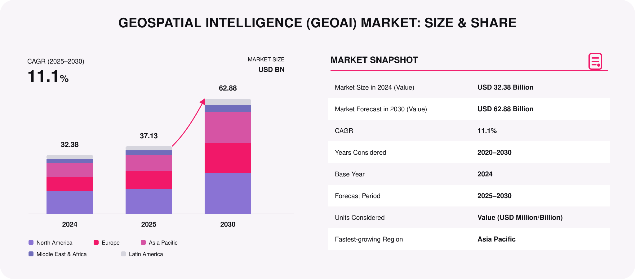
GIS is used to track patterns and gain insights for property valuation, city infrastructure planning, business management — you name it. But it can automate geospatial analysis only to an extent: someone still has to decide what to look for. GeoAI is what takes things up a notch — it finds the patterns instead of waiting to be pointed at them.
Under the hood, GeoAI cross-integrates GIS (and other systems handling remote sensing data) with a stack of AI technologies:
- ML and deep learning models
- Сomputer vision and natural language processing
- IoT and cloud platforms
- Big data analytics and smart predictions
As such, the use of geoAI in property assessment allows for reading into and interpreting geospatial patterns, instead of just mapping them. For this, the geoAI collects rich spatial inputs from disparate sources, which include:
-
Satellite imagery: panoramic views of objects and surroundings (help track land cover changes and structural footprints).
-
Aerial photos and LiDAR: high-resolution, up to centimeter-level precise images (help visualize shapes, heights, and textures of buildings).
-
Cadastral maps: officially documented outlines that provide property boundaries, ownership details, and parcel identification numbers (help manage parcel PINs for taxation and legal needs).
-
IoT sensors and additional datasets: data on environmental, socioeconomic, and infrastructure specifics sourced from smart devices or public records (help monitor the urban or housing situation in real time).
However, the main point of difference from traditional GIS here is that the geoAI “understands” and harmonizes all the data that it’s ingested with. In simple words, thanks to deep learning and computer vision algorithms, geoAI is trained to recognize and classify various geospatial features: roads, buildings, vegetation, water bodies, etc.
But geoAI doesn’t simply register what exists—it identifies where and how it has changed over time, autonomously updating databases and visualizations. Thus, thousands (even millions) of parcels can be analyzed rapidly, followed by the automated extraction of features.
Why GeoAI Is a Game-Changer for Property Assessment
When implemented properly, GeoAI helps minimize manual inspections, field surveys, and analysis of historical sales without risking the precision of real estate valuation. There are four big aspects where using geoAI for property assessment stands out as a superior approach.
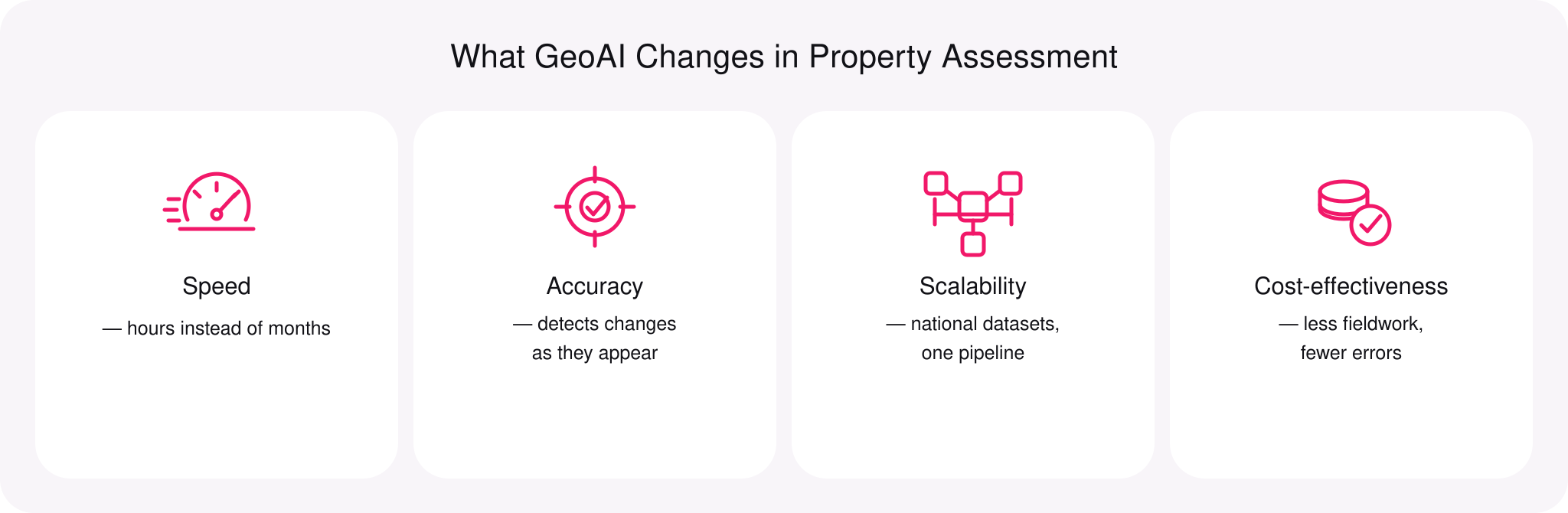
Speed
Automated mapping with the help of AI-driven image processing enables mass analysis of thousands of parcels in hours instead of months. Furthermore, with high-resolution imagery and object recognition through computer vision, there’s no need for every assessor to visit a site physically.
Accuracy
By processing dynamically updated satellite and aerial imagery through spatial analytics, GeoAI delivers consistent and up-to-date valuations. For example, it can almost instantly detect changes in roof condition, property expansions, or new construction. This allows for a highly accurate tax assessment.
Scalability
Cloud platforms and machine learning enable valuation across regional or national datasets. By using geoAI for property assessment, you can integrate diverse data streams—from cadastral and public records to land registry inputs to sensor feeds. This scale was previously unimaginable without a lot of human resources invested.
Cost-effectiveness
Integrating geoAI results in less fieldwork, automated mapping, and consistent data pipelines. All of that, combined with flexible cloud tariffs, can help lower operational costs throughout. At the same time, it also helps minimize human errors inherent in traditional tax rolls and appraisal systems.
See how drones capture imagery
Core Applications of GeoAI in Property Assessment
There can be plenty of cases of using geoAI in property assessment, but its main applications come down to the following ones.
Automated cadastral mapping
GeoAI algorithms identify parcel boundaries and buildings’ footprints automatically from spatial imagery and computer vision models. The CV models can segment and classify land features based on patterns in pixel data. This results in highly precise polygon geometries.
Automated cadastral mapping enables consistent tax records and land registry updates. Every parcel is processed by the same intelligent pipeline, using reproducible criteria and spatial logic. It also reduces the need for manual digitization and urgent cadastral updates.
Valuation modeling
GeoAI can integrate datasets with socioeconomic and environmental indicators to predict potential property values. For instance, deep AI models can learn from geospatial features, neighborhood characteristics, and local market dynamics. They can recognize roof quality, building style, footprint size, and recent renovations.
This allows them to produce valuation predictions that are simply unachievable with traditional regression methods (like hedonic regression). GeoAI also generates time-aware predictions, without empty statistical assumptions. E.g., a convolutional network AI will tell how a building arrived there and where it might be going in the immediate future.
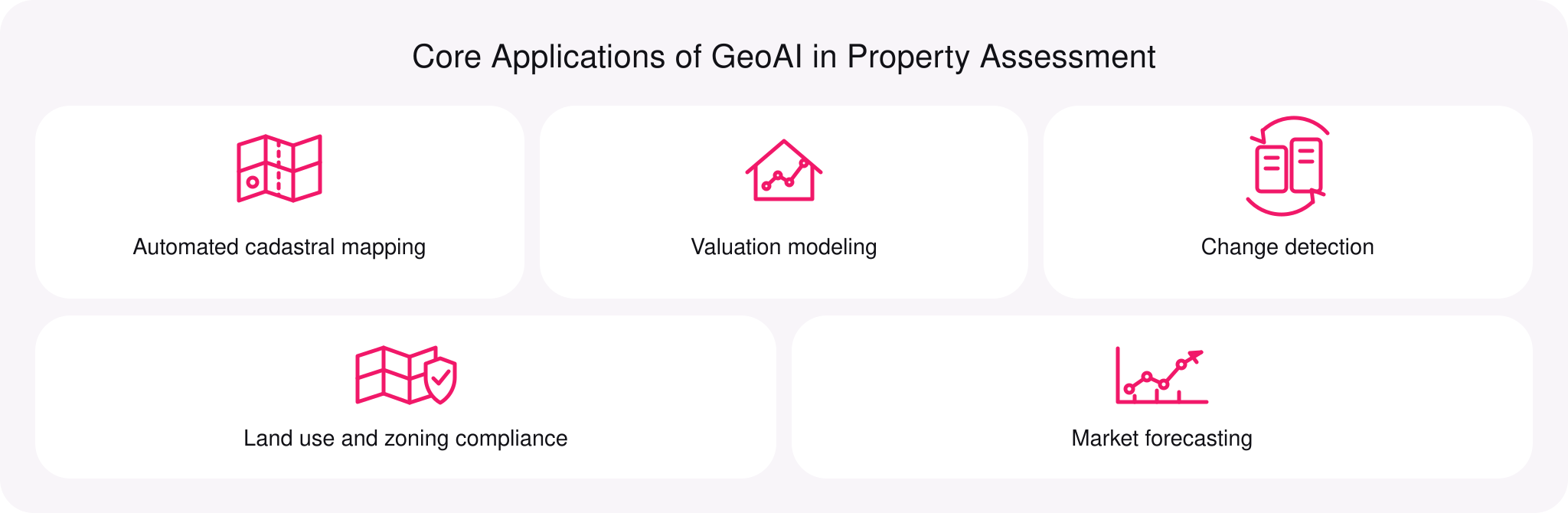
Change detection
As you can see, GeoAI can easily detect new construction, renovations, demolitions, or undeclared modifications in the monitored area. For this, a deep geoAI model compares time-series imagery—two or more time-based geospatial images. For example, it may compare satellite or aerial photos from last year with those from today.
GeoAI instantly alerts assessors about recently altered properties. But unlike simple pixel-by-pixel comparison, deep change detection algorithms also focus on interpreting what has changed and why (not only when and where). The automated change detection helps avoid inaccuracies in taxation systems and compliance issues.
Land use and zoning compliance
GeoAI enables thorough land use monitoring, helping to track ownership and exploitation patterns, as well as zoning compliance issues. E.g., you can track down unauthorized land conversions immediately—a geoAI model analyzes multiple spatial layers and alerts human specialists about any anomalies.
Local authorities can use this to enforce fair regulations and integrate any findings with urban analytics. They can also use it to continuously monitor urban fringe zones, floodplains, and protected ecological regions.
Market forecasting
Machine learning models can be set to analyze trends in infrastructure changes, location desirability, and demographic shifts. For instance, they can track proximity to transit, schools, healthcare, green spaces, and amenities. For larger-scale projects, e.g., city infrastructure valuation, they can factor in new rail lines, highways, and business hubs.
Going deeper still, a geoAI can track population growth and migration patterns. With all this data processed, an ML algorithm can predict where major housing demand and price shifts may happen next. These are highly valuable insights for taxation systems and urban planners.
Demand Forecasting Solution for Transportation Services
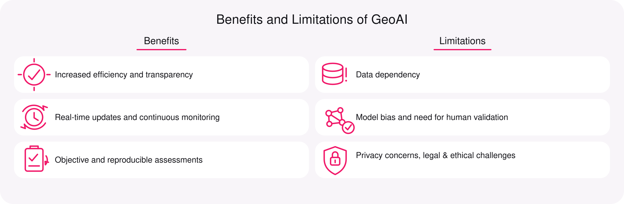
Benefits and Limitations of GeoAI
Using geoAI for property valuation is a highly efficient solution that’s already showing its benefits, but its entire potential is yet to be unravelled in practice. For now, it has its own limitations as well. Let’s take a look at both.
Benefits
Increased efficiency and transparency
GeoAI dramatically accelerates the traditionally labor-intensive process of property assessment. Namely, by automating large parts of data collection and analysis. By using geospatial intelligence and automated mapping, governments and assessors can cut their dependence on manual fieldwork, minimizing both human error and subjective judgment.
This efficiency doesn’t just save time but entirely transforms workflow quality. Automated systems with clear, documented logic also make it easier for stakeholders (e.g., taxpayers, auditors, planners) to trace each valuation case. For instance, you can trace valuations down to their derivatives. For stakeholders, this means the ultimate transparency.
Real-time updates and continuous monitoring
Traditional valuations must rely on episodic site visits and static records. Those are sure ways to leave new buildings, renovations, demolitions, and other significant changes unnoticed for months (years even). In turn, GeoAI integrates change detection based on regularly updated satellite or aerial imagery.
The model then flags modifications automatically, keeping all property data synchronized with each and every change in reality. Such dynamic visibility enables assessments that reflect current conditions rather than outdated estimates, boosting the overall data quality. This is especially relevant for rapidly evolving urban environments.
Objective and reproducible assessments
One of the most standout advantages of GeoAI is that it can analyze thousands of properties based on consistent criteria. That is next to impossible with manual valuation practices, where every other assessor can have a unique experience. Local interpretations may differ a lot, lacking in objectivity.
Alternatively, geoAI models use uniform valuation logic that is built based on specific spatial features, economic indicators, and structural characteristics. The resulting automated assessments are heavily data-driven and easily reproducible. Reducing bias, such assessments also help preserve equity across diverse neighborhoods. But the efficiency of all that depends on the quality of the model training.
Limitations
Data dependency
GeoAI models require large volumes of up-to-date, accurate geospatial imagery and ancillary data. For flawlessly consistent valuation results, the data quality for model training must be as high as possible. If any bad data seeps in, it must be filtered and thrown out according to the famous “garbage in, garbage out” AI principle.
Any gaps, inconsistencies, or outdated cadastral records can skew outputs or reduce confidence in the results. In regions with sparse data (e.g., rural or developing areas), model performance may degrade, producing weaker predictions than those in well-digitized urban settings.
Model bias and need for human validation
Even with thorough automation, geoAI cannot depend on computational resources only, requiring occasional validation by human experts. An ML model learns patterns from historic records, and it’s important to ensure the training data doesn’t reflect any past inequalities. E.g., a poorly monitored geoAI may register lower valuations in underserved neighborhoods due to socioeconomic bias.
Moreover, many deep learning architectures operate as “black boxes”—i.e., their internal decision logic is not easily explainable. This lack of transparency can make it difficult for assessors, regulators, or property owners to fully validate AI outputs. This would require a human-involved workflow, where experts review and refine the geoAI model’s logic.
Let’s build a solution tailored to your needs
Privacy concerns, legal & ethical challenges
GeoAI’s reliance on geospatial and sometimes personal location data may raise privacy concerns. Certain location signals can be very privacy-sensitive, like the data on ownership, cadastral blueprints, or protected sensor networks. If you mishandle them, you will risk breaking legal regulations and/or public trust.
GeoAI must be used responsibly, with all relevant ethical frameworks and regulatory compliance tasks fulfilled. In particular, in jurisdictions with strict data protection laws. On top of that, we are looking at potential security risks such as unauthorized access or misuse of spatial information. This also requires governance.
Conclusion
GeoAI is reinventing property assessment as we know it, maximizing fairness, efficiency, and transparency of geospatial analysis. By fusing spatial intelligence with deep learning and cloud computing, assessors can achieve valuations that reflect real-world dynamics, with reliable consistency and an extreme scale of diverse data inputs.
But the true promise of GeoAI is not at all just about technology. It is about a new level of collaboration between GIS professionals, AI experts, urban planners, and government agencies. Joining forces, they can now build systems that are equitable, responsible, and insightful.
Are you currently exploring how GeoAI can elevate your property assessment processes? Contact Requestum for a consultation on implementing AI-powered geospatial solutions tailored to your specific goals.

Our team is dedicated to delivering high-quality services and achieving results that exceed clients' expectations. Let’s discuss how we can help your business succeed.



SHARE: