ABOUT THE AUTHOR

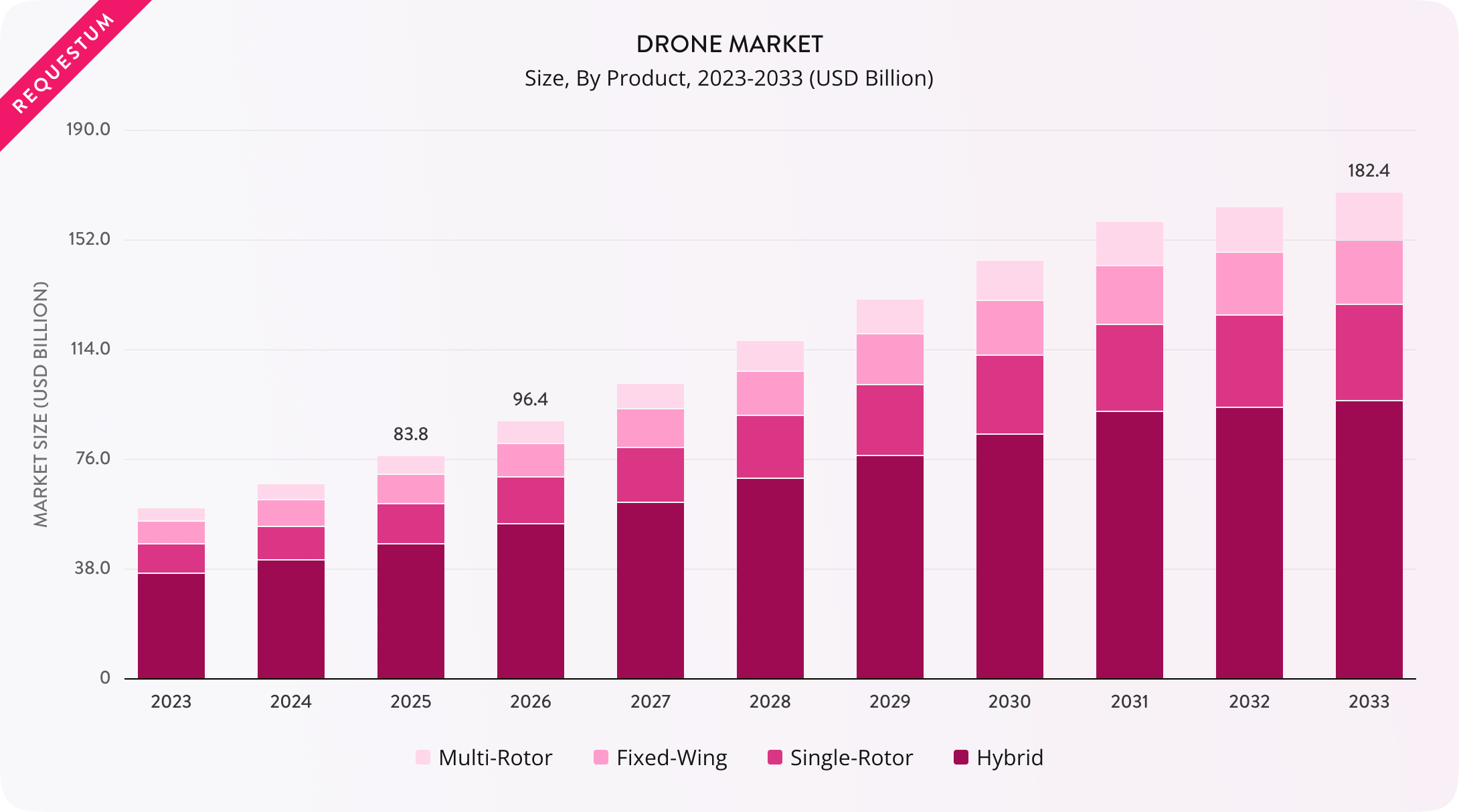
The rapid growth of the global drone market is the best demonstration of the spread of the technology. For instance, in the last year, the drone market size was estimated at 83,808 million USD, and by 2033, it is projected to reach 182,449 million USD.
Computer vision for drones lies at the core of the industry transformation. It enables accurate picture interpretation and better interaction with the environment. Modern UAVs rely on CV for tasks such as object detection and navigation, scene understanding, and object analysis. A CV is also a vital feature for autonomous flight and mission execution.
In this article, we will review how AI drone technology can make a difference in the industry competition. We will explain how CV works in modern drones and what applications are the most significant for business. We will explain what kind of challenges to expect and how to prepare. With our simple comparison of custom vs. off-the-shelf solutions, you can consider which option best suits your business.
What Is Computer Vision for Drones?
Computer vision is the use of AI-based visual recognition and analysis technologies that allow drones to capture, process, and interpret images, videos, and spatial data from the environment. Instead of simply recording footage, drones with computer vision can detect objects, recognize patterns, measure distances, identify defects, and support automated decision-making.
Modern unmanned aerial vehicles (UAVs) are often equipped with high-resolution cameras, depth sensors, and advanced systems. All the components continuously capture visual and spatial data when the drone moves. The raw data means nothing, but after the CV transformation, it becomes a source of meaningful information, such as objects around, estimated distances, etc. For example, drones for infrastructure inspections can detect cracks and defects.
At the core of this function are advanced AI models, such as neural networks (CNNs) and vision transformers. CNNs are trained on huge datasets of images and videos and can recognize patterns and classify objects. And with a stable source of accurate predictions, companies will always stay informed.
A key difference between traditional camera-equipped drones and computer vision drones is UAV autonomy. Traditional drones work primarily as remotely controlled platforms that can only capture and transmit video to a human responsible for decision-making. CV-powered drones can analyze visual data onboard and make decisions in real time. It enhances efficiency, especially in environments where real-time human response is limited.
Explore the top computer vision development companies
How Does UAV Computer Vision Work?
With computer vision, drones can transform captured information into reasonable actions through several stages. Let’s take a look at each one of them closely.
Image capture
The whole process starts with data acquisition via onboard sensors. Most modern UAVs are equipped with RGB cameras that can capture standard visual imagery. More advanced platforms can also integrate thermal cameras for heat signature detection. For agricultural drones, multispectral sensors can be especially valuable for analyzing vegetation health. With LiDAR systems, drones can also generate 3D maps of surrounding areas.
Data processing
Captured data should be efficiently processed. Modern drones rely on edge computing, in which data is analyzed locally using embedded GPUs or AI accelerators. Such an approach enables immediate responses.
In contrast, cloud-based processing enables the offloading of large datasets for deeper analysis. It will be especially valuable for long-term mapping and pattern recognition across several flights. Cloud processing, however, relies on network connectivity and, as a result, may add delays.
To deal with this problem, companies often adopt hybrid architectures that combine real-time onboard processing with cloud-based analysis. It helps balance analyzing power and speed.
Visual data interpretation
Artificial intelligence models are responsible for clear visual data interpretation and advanced drone object detection. Detection algorithms such as YOLO and SSD are widely used to identify and localize objects in images. Classification models provide categories for object detection, while segmentation algorithms divide scenes into meaningful regions, enabling a precise understanding of boundaries and surfaces.
Real-time interference
After analysis, a drone can perform real-time inference and make decisions based on the processed information. Drone image recognition enables instant response to environmental changes, avoiding obstacles, tracking moving targets, or adjusting the flight route. In this case, drones can operate safely and efficiently even under unpredictable conditions.
By integrating sensing technologies and efficient computation with AI-driven algorithms, UAV systems can achieve higher operational efficiency and autonomous navigation.
Key Applications of Computer Vision in Drones
Based on our experience, computer vision extends drones’ capabilities, enabling more efficient decision-making and better control over product quality. In many industries, a CV serves as a tool for accurate defect detection and perimeter monitoring. In this part, we invite you to discover the most significant CV applications, with real-world examples.
Infrastructure and industrial drone visual inspection
Drones, empowered by computer vision, can automatically inspect large-scale infrastructure. They can detect structural issues such as cracks, corrosion, or electrical faults. A high-resolution camera and AI-based analysis can easily replace manual inspection, covering hard-to-reach areas such as wind turbines, power lines, pipelines, and bridges. For example, researchers provided drone-based bridge monitoring to detect structural deformation and damage, such as cracks and surface issues.
Precision agriculture
In agriculture, computer vision is used for crop health monitoring and early disease detection. It enables weed identification and yield prediction. With multispectral cameras, farmers can analyze vegetation indices such as NDVI and better understand the current state of plant health. As a result, they can optimize irrigation and fertilization, applying them more efficiently. For instance, drone-based multispectral imaging is applied to monitor crop growth variables.
Surveillance and security
Drone computer vision object detection is a perfect solution for real-time surveillance tasks such as perimeter monitoring or crowd behavior analysis. It enables fast and accurate anomaly detection and automates license plate recognition. With such systems, companies can reduce the need for human monitoring and improve reaction time during security operations. For instance, Skydio develops autonomous drones for industrial sites and infrastructure protection. They can navigate complex environments, scanning territory for threats.
Search and rescue operations
In disaster areas, drones equipped with thermal imaging cameras and object detection systems can be a great help during search operations. For example, they can locate mission people in collapsed buildings. Empowered with computer vision, they provide enhanced visibility in low-light or damaged environments, significantly improving rescue chances. As a real-life example, you can see Rega's search-and-rescue team, which uses drones to locate missing hikers in mountainous terrain.
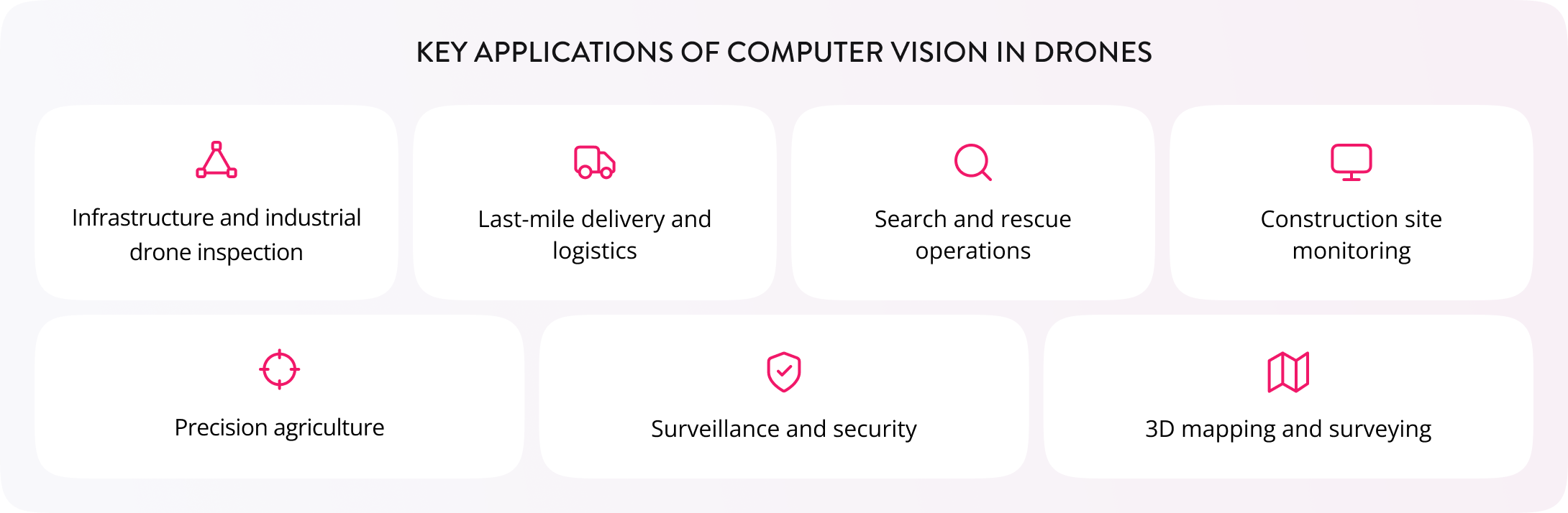
Last-mile delivery and logistics
Computer vision drone navigation enables autonomous delivery, allowing for efficient obstacle avoidance, safe landing, and even package verification. It means AI-driven drones can operate in complex urban environments and deliver goods accurately without manual control or intervention. For example, Zipline uses drones to provide deliveries.
3D mapping and surveying
Drones utilize computer vision algorithms such as photogrammetry and point cloud generation to create highly detailed 3D maps of structures and terrain. These models can become especially valuable for complex construction planning and mining operations. Skycatch, for instance, utilizes modern drone technologies in surface mining.
Construction site monitoring
With computer vision on drones, construction companies can track project progress more efficiently. This way, experts can compare site conditions with digital blueprints to detect safety violations or construction weaknesses at an early stage. Real-time detections improve overall project efficiency and reduce costly errors and the delays required to fix them. Pix4D, a Swiss company, uses drones to compare the as-built construction state with the digital project and detect violations and errors before they can cause damage to the project.
Technologies behind computer vision in drones
Now, let’s have a closer look at the technologies that make computer vision drones so effective.
Deep learning and neural networks
Neural networks (also known as CNNs) and transformer-based models enable autonomous navigation and accurate target detection. With their help, drones can provide accurate mapping and perform decision-making without human guidance. Machine learning for drones teaches AI models to interpret images and video, detecting objects and recognizing patterns.
Edge computing and embedded AI
Models like NVIDIA Jetson and Qualcomm Snapdragon run directly on the drone’s hardware, eliminating latency and potential delays. With such advanced models, drones can make real-time decisions and operate without an internet connection, improving their reliability during critical missions.
Sensor fusion
The combination of data from multiple sensors, including RGB cameras, LiDAR, infrared, and IMU, produces a more accurate and robust understanding of the present conditions. It enables safe navigation in low-light zones and effective depth measurements. Several sensors also ensure stability in case one fails to operate under specific conditions.
Cloud integration and telemetry
All collected data is sent to cloud systems for further model retraining. Large-scale data analysis is a powerful approach to continuous improvement of artificial intelligence models. Automated reporting, enabled by cloud integration, ensures that operators are always informed about the current situation and potential risks.
5G and real-time data transfer
Advanced technologies enable high-speed, low-latency wireless connections between drones and operators, ensuring stable remote control when required. This way, operators can perform live video streaming and coordinate multi-drone tasks with minimal delay.
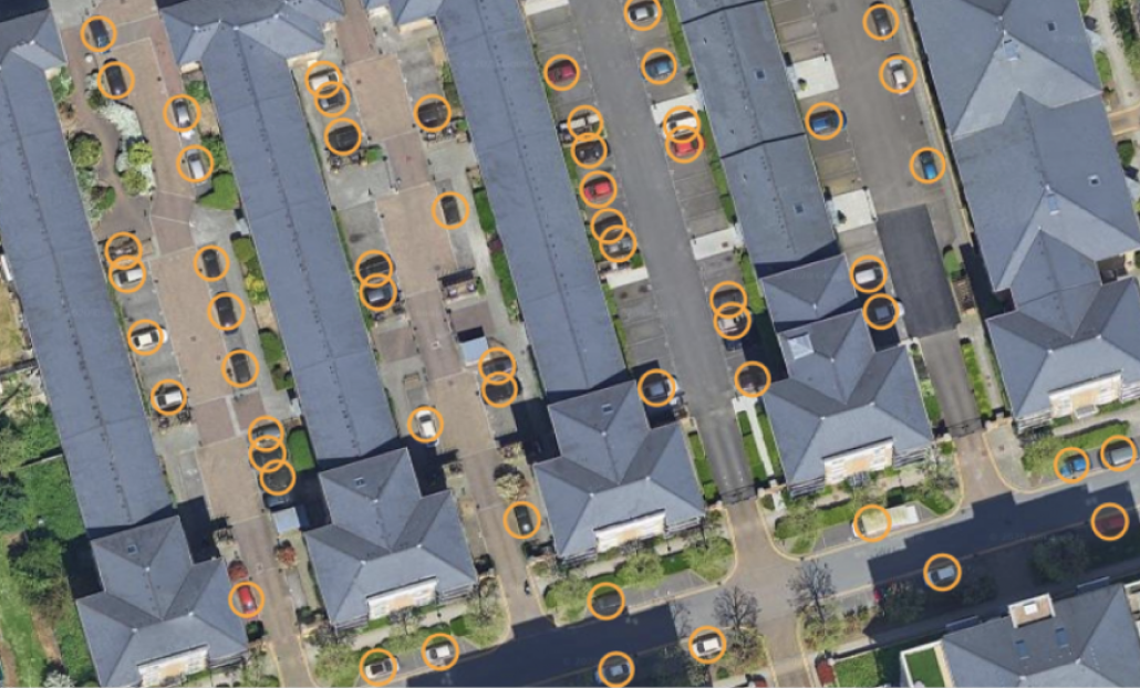
Detection of cars on overhead images
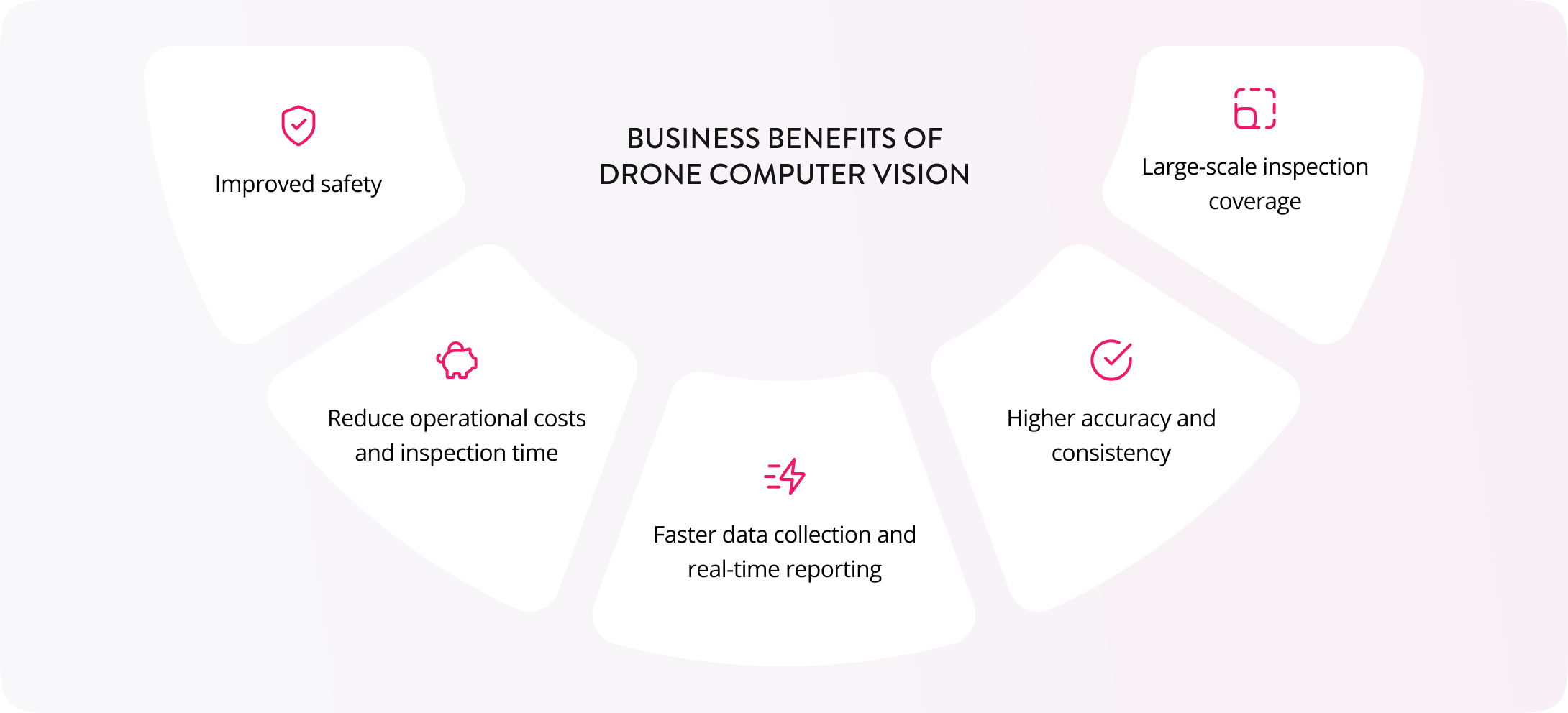
Business benefits of drone computer vision
Drones offer a wide range of benefits depending on the industry in which they are used, but for now, we want to focus on the 5 most valuable aspects for businesses across industries.
Reduced operational costs and inspection time
Drone use reduces the need for human labor and saves a lot of time by enabling fast, accurate inspections in the hardest-to-reach areas, like bridges and pipelines. For example, according to JIW's experience, the cost per bridge can be reduced by up to 75%, making inspections more affordable without compromising quality.
Improved safety
Drones can replace the need for humans in high-risk areas. For example, instead of sending human agents to potentially dangerous areas such as disaster zones or heights, companies can minimize human presence to the bare minimum and use remote control of operations when possible.
Higher accuracy and consistency
AI-powered inspection offers higher accuracy and reduces the risk of human error and fatigue. Computer vision algorithms can apply the same criteria repeatedly and detect defects invisible to the human eye.
Large-scale inspection coverage
Large-scale operations require dozens of human inspectors to cover the entire area, whereas a single drone system can easily inspect hundreds of kilometers per day. Autonomous navigation and decision-making algorithms, combined with AI analysis, scale without incurring linear labor costs.
Faster data collection and real-time reporting
Data processing performed by humans takes several days or weeks, depending on the scale of the information, but computer vision drones provide instant access to real-time data. It enables real-time data reporting and decision-making for fault detection and emergency responses.
Challenges and Considerations
According to the Requestum experts’ opinion, the following challenges may get in the way, so it is better to consider them to avoid difficulties when using computer vision drones.
Training data quality
AI models require large and high-quality labeled datasets for training. Naturally, their creation is expensive and very time-consuming, but without a proper data feed, the model may function with errors. High-quality data ensures high stability and accuracy.
Environmental variability
Training should include operations under variable weather and environmental conditions to ensure the models know how to act in specific situations. We recommend training under different lighting conditions, weather simulations, and occlusions to understand how these factors affect model accuracy in the field.
Let’s build a solution around your business goals
Hardware constraints
For effective drone operation, you need to balance computing power, battery life, and payload limits to achieve the best possible quality and efficiency.
Regulatory compliance
Drone flight regulations and data privacy laws may vary by region. We recommend checking the current requirements and regulations to avoid problems in the area where you plan to operate computer vision drones.
Integration complexity
Integration is not an easy task, as you need to connect drone CV output with your existing business systems and workflows. It also required agent training to achieve the best possible results and correct technology use.
Cybersecurity
Data security is one of the most essential factors for any business, and we recommend ensuring that all streams have robust data protection measures. It is important to establish a secure connection that prevents unauthorized drone access.
Custom Development vs Off-the-shelf CV Solutions
There are two options for drone AI software: off-the-shelf computer vision solutions and custom development programs. Here, we will compare these types of solutions and outline the pros and cons of each.
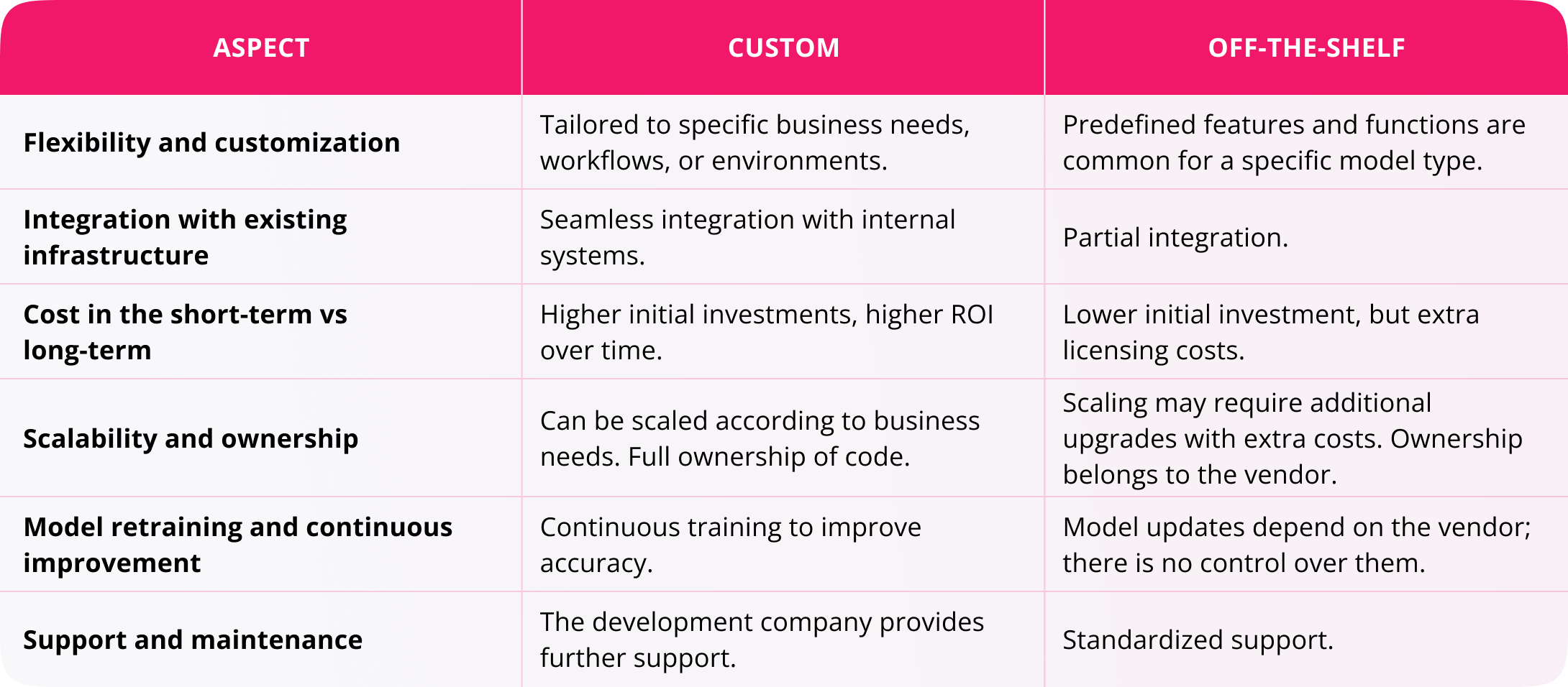
Off-the-shelf tools can be a good option to start with when you need to handle simple, standardized tasks. But for companies operating in complex environments, custom drone software may provide a strategic advantage.
Conclusion
Computer vision is an essential tool that makes drones smarter, safer, and more valuable for businesses. Naturally, using CVs poses challenges related to safety, the need for high-quality data, and understanding modern regulations, but the opportunities it offers companies are worth it. With computer vision drones, humans don’t have to spend long periods of time in potentially dangerous areas and can control the process remotely, staying safe. It enables instant access to valuable data and allows machines to perform routine tasks without the need for human intervention.
If you're ready to update inspections and area control with modern custom drone CV solutions, Requestum experts will be glad to consult and create software fully tailored to your needs.

Our team is dedicated to delivering high-quality services and achieving results that exceed clients' expectations. Let’s discuss how we can help your business succeed.
SHARE: